 344-9999")


LiDAR system and its main industrial applications
A LiDAR system is a remote sensing technology that’s transforming how businesses capture and process data from industrial environments. Originally developed for geospatial and automotive applications, this tool is now gaining ground in warehouses and distribution centers (DCs) due to its ability to generate highly accurate 2D and 3D maps.
In this post, we explain what LiDAR is, how it works, and where it’s being leveraged in logistics and industrial settings.
What is a LiDAR system?
LiDAR (short for light detection and ranging) is a remote sensing technology that uses laser pulses to measure distances with exceptional precision. A LiDAR system scans surfaces, identifies objects, and creates three-dimensional representations of environments. LiDAR has been widely adopted across industries such as agriculture, automotive, and robotics and is now making inroads in logistics and intralogistics.
LiDAR is part of a broader set of spatial perception technologies that include ultrasonic sensors, cameras with SLAM navigation (simultaneous localization and mapping), and computer vision systems. Compared to ultrasonic sensors, which rely on acoustic waves and have a limited range, LiDAR stands out for its speed, resolution, and ability to perform in low-light or harsh environments.
There are several types of LiDAR systems, typically classified based on their scanning method, platform, and sensor technology. Each configuration is tailored to specific needs in terms of range, accuracy, data capture speed, and environmental resistance.
How does a LiDAR sensor work?
A LiDAR sensor emits laser pulses and measures the time it takes for them to bounce off objects and return to the sensor. This process applies the classic distance calculation formula using the speed of light: by knowing how fast the laser travels (about 186,000 miles per second) and measuring the round-trip time of each pulse, the sensor accurately calculates the distance to the object.
The process takes place in three main stages:
- Pulse emission. LiDAR sensors can emit millions of laser pulses per second in a particular direction.
- Pulse reflection. These pulses hit surfaces or objects in the environment (e.g., buildings, trees, vehicles, or the ground) and reflect back toward the sensor.
- Reception and calculation. The sensor records the time between the pulse emission and return. Using these data, the system calculates distances and generates a 2D or 3D point cloud that precisely represents the environment.
LiDAR scanners can be mounted on mobile platforms (vehicles, drones, and robots) or installed in fixed positions. They typically rotate or scan in multiple directions to capture detailed three-dimensional data from their surroundings.
LiDAR system applications
LiDAR technology has become a vital tool in multiple industries thanks to its ability to generate detailed 2D and 3D maps in real time. While it was originally used in fields like topography and geology, its applications now extend to sectors such as logistics, industrial automation, and mobility.
- Autonomous vehicle navigation. Automatic guided vehicles (AGVs) and autonomous mobile robots (AMRs) employ LiDAR sensors to detect obstacles, follow routes, and operate safely within logistics facilities and manufacturing plants.
- Drones. Equipped with LiDAR sensors, drones perform aerial infrastructure inspections, monitor farmland, and map terrain with high precision.
- Smartphones and tablets. Some mobile devices integrate LiDAR sensors to enhance augmented reality, scan spaces, and deliver fast 3D measurements.
- Automotive. LiDAR helps self-driving vehicles identify pedestrians, other vehicles, and environmental elements, improving navigation and safety.
- Construction and architecture. LiDAR sensors mounted on drones, terrestrial scanners, or handheld devices can scan buildings, generate 2D and 3D plans, and monitor construction progress.
LiDAR’s versatility makes it an essential technology for digitalizing physical environments, optimizing operations, and boosting efficiency in increasingly connected industries.
LiDAR system in logistics
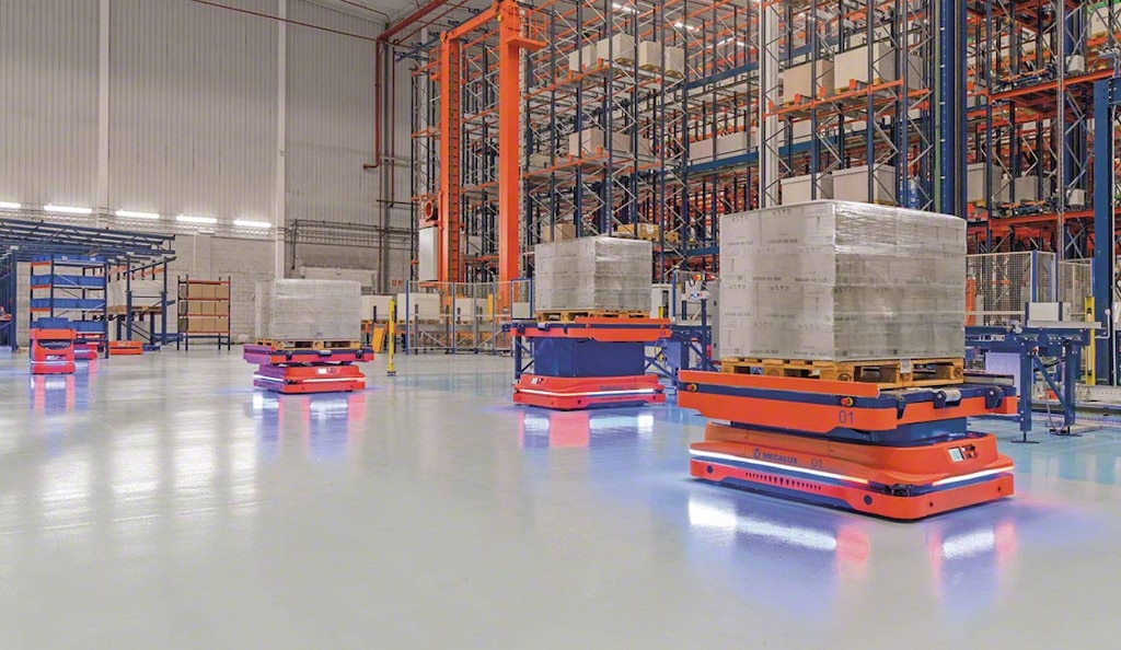
In logistics, LiDAR systems are primarily leveraged by AMRs, AGVs, and storage systems to optimize navigation, avoid obstacles, automate inventory control, and maximize warehouse space utilization.
Autonomous mobile robots (AMRs) equipped with LiDAR sensors can safely travel in logistics environments, circumventing obstacles and adapting to changes around them. For instance, Interlake Mecalux’s AMRs integrate LiDAR technology to ensure precise, safe, and efficient navigation, even in dynamic settings with constant movement of people and equipment. This technology is often combined with SLAM navigation systems, which enable robots to map their surroundings and localize themselves without relying on external infrastructure.
Certain drones and robots also utilize LiDAR to scan racking and inspect stock levels without human intervention, streamlining inventory management.
Overall, integrating LiDAR systems in logistics environments offers numerous benefits that raise operational efficiency and support process automation.
LiDAR: A key technology for future-forward logistics
LiDAR systems have become crucial for automating warehouses and DCs. Their ability to generate maps, sense obstacles, and provide accurate real-time data makes them an effective tool for improving productivity, safety, and adaptability in logistics operations. In a sector increasingly driven by technology, LiDAR is opening up new opportunities to transform intralogistics through smart, connected solutions.
LiDAR system in 5 questions
What is a LiDAR system?
LiDAR (light detection and ranging) is a technology that employs laser pulses to measure the distance between an emitter and an object or surface by calculating the time it takes for the reflected light to return to the sensor.
What is LiDAR technology used for?
LiDAR scanners capture highly accurate and fast topographic and spatial measurements. They create 2D and 3D point clouds applied in mapping, forest management, urban planning, civil engineering, archaeology, logistics, and other fields.
What types of LiDAR are there?
Airborne LiDAR, mounted on airplanes and helicopters, scans large areas from the air and includes both topographic and bathymetric variants. Terrestrial LiDAR — either static or mobile — is used to scan buildings, infrastructure, and terrain with high point density.
What’s the difference between a laser sensor and LiDAR?
A basic laser sensor detects presence or distance. A LiDAR system is more advanced; it emits laser pulses, measures their return time, and generates accurate 2D and 3D maps with help from GPS and navigation systems.
Does LiDAR scan in 3D?
Yes. LiDAR generates 3D point clouds that accurately represent surfaces and nearby objects. This enables detailed spatial analysis for a wide range of applications, from digital maps and autonomous navigation to inventory control.